
Traveling in Alaska
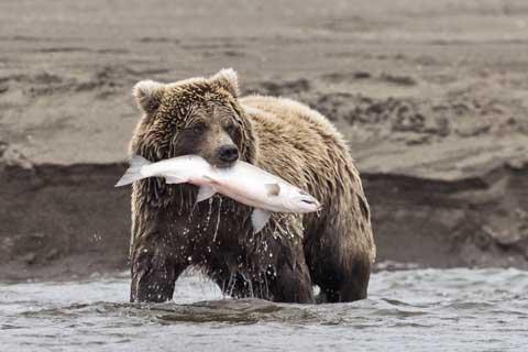 The wilderness of Alaska
Alaska joined the United States of America as the 49th state. The US purchased the area from the Russian Empire in 1867 for just 7.2 million dollars (about two cents an acre). It became an organized territory in 1912 and a state in 1959. It is separated from the rest of the country by Canada and, although it is the largest state, it is the least densely populated and for many years had the lowest population. It covers an area equal to California, Texas and Montana combined and lies on the Arctic Circle. Many people consider Alaska to be the United State's "final frontier" because of its vast wilderness. It is also where you will find the highest point in North America.
Because Alaska is so large with such a range of elevations, the climate is quite diverse. The climate in the southeast is a mid-latitude or subarctic oceanic climate. This is the wettest and warmest part of the state. In Anchorage and the south central part of the state the climate is milder than most areas with less rain. Western Alaska is effected by the Bering Sea and the Gulf of Alaska. It receives a lot of precipitation but has milder temperatures than you might expect. Interior Alaska is subarctic. Here you will find both the highest and lowest temperatures in the state.
Regions
Alaska can be divided into five regions. Southeastern Alaska includes the Panhandle and Inland Passage. Southcentral Alaska includes Anchorage and the Kenai Peninsula. Southwestern Alaska includes the Alaskan Peninsula and the Aleutian Islands. Interior Alaska is where you will find Fairbanks and Arctic Alaska is where you will find Barrow, Nome and Kotzebue.
 Budget Your Trip is all about finding out how much everything costs so that you can travel cheaper and longer. Created by avid travelers Laurie and Bryan, our goal is to help you plan your next trip on the right budget. With average daily travel costs that are calculated from the budgets of real travelers, plus an analysis of hotel and tour prices, you can find out how much money you need to plan your next adventure. We also have plenty of travel advice, accommodation reviews, and activity suggestions.